 |
URBAN GEOGRAPHY
Definitions of Urbanism
Urbanism
is the process through which cities grow. There are a variety of definitions of
cities that are used in the AP Human Geography course. Most of them are specific
to the United States and will probably vex students from other countries.
Historically, it was relatively easy to define the differences between urban and
rural settlements because cities were surrounded by walls. The removal of the
walls and the rapid territorial expansion of cities during the modern period as
well as the changing nature of agriculture have blurred the distinction of the
physical differences between cities and urban areas. Today, urban settlements
are defined by legal boundaries, a continuously built-up area, or as functional
area. The legal definition of city varies around the world but is significant
because legally defined, cities have certain sorts of political power such as
the ability to raise taxes, provide services, and have their own elected
officials. Sometimes, in the U.S., a city surrounded by suburbs (which are also
cities) is defined as a central city. Confusion over the definition of "city" is
a problem.
These definitions are arbitrary, and significant class time should not be spent
on them. In the U.S., an urbanized area is usually defined as a central city
plus its contiguously built-up suburban area where the population exceeds 1,000
persons per square mile. About 60 percent of the U.S. population lives in urban
areas so defined. Another definition of a metropolitan statistical area (or MSA)
includes the center city, which must have a population of 50,000, the county in
which the city is located, and the adjacent counties with at least 15 percent of
their residents working in the center city's county. These counties must also
have 60 persons per square mile or at least 65 percent of their residents
working in farm jobs. SMSAs are widely used in discussions about urbanization in
the United States because the Census gathers information about them. However,
because they are based on counties, they are tricky to use because many of the
large counties in the west include parks or wilderness areas. For example, the
MSA in Duluth involves the Boundary Waters Canoe Areas that is an officially
sanctioned wilderness. SMSAs are also prone to overlap in areas where
populations tend to grow rapidly. So there is another category called the
Consolidated Metropolitan Statistical Areas (CMSA).
Origin and Evolution of Cities
Industrialization is frequently considered as the replacement of farming and resource extraction by manufacturing and service activity. This transition takes different forms in different places at different times. Geographies of industrialization and economic development are important in understanding future growth patterns.
Historical Patterns of Urbanization The first cities occurred when one member of an agricultural village focused totally on nonprimary production activity. The definition, of course, would not fit contemporary cities at all, but in the analysis of the evolution of cities, we must understand that cities are functional places not necessarily defined by size like the Census Bureau's definition. Cities in ancient times were mostly associated with the formation of the state. One of the main functional definitions of cities is the establishment of some sort of ruler or elite class to create a political system or structure that would govern the population.
Urban areas began approximately 7000 years before present. This was the so-called formative stage. Cities and their states were beginning to develop in southwestern Asia particularly in the Tigris and Euphrates' basins. Other areas where urbanization occurred very early were the Indus Valley, the Nile Valley, and the great valleys of China. Urbanization also developed in Central America, the Maya Aztec area, and the Andean area of South America. These early cities were theocratic, where the rulers had divine authority and were in essence, "god-kings."
The ancient city expanded from southwest Asia through Greece to Europe. The Roman Empire developed massive urban systems based on a network that would move goods from Hadrian's Wall separating Britain from Scotland, to the upper middle Nile, to the Red Sea coast and the Caspian Sea and Persian Gulf. We can categorize cities in terms of the degree to which they have been industrialized. We can think of societies as folk, preliterate, feudal, preindustrial, and urban industrial. Cities continue along a continuum.
Cultural Context and Urban Form One of the main types of cities is called the primate city. These tended to be preindustrial cities although they exist in the world today. Primate cities embody all the major features of the culture. They are also defined statistically as having more than twice the population of the second largest city. Primate cities are best considered in terms of their cultural impact. They are the centers of the population's culture, and people feel they must be in the primate city in order to be successful.
A country's leading city is always disproportionately large and exceptionally expressive of national capacity and feeling. The primate city is commonly at least twice as large as the next largest city and more than twice as significant. - Mark Jefferson, 1939
Geographer Mark Jefferson developed the law of the primate city to explain the phenomenon of huge cities that capture such a large proportion of a country's population as well as its economic activity. These primate cities are often, but not always, the capital cities of a country. An excellent example of a primate city is Paris, which truly represents and serves as the focus of France.
They dominate the country in influence and are the national focal-point. Their sheer size and activity becomes a strong pull factor, bringing additional residents to the city and causing the primate city to become even larger and more disproportional to smaller cities in the country. However, not every country has a primate city, as you'll see from the list below.
Some scholars define a primate city as one that is larger than the combined populations of the second and third ranked cities in a country. This definition does not represent true primacy, however, as the size of the first ranked city is not disproportionate to the second.
The law can be applied to smaller regions as well. For example, California's primate city is Los Angeles, with a metropolitan area population of 14.5 million, which is more than double the San Francisco metropolitan area of 6.3 million. Even counties can be examined with regard to the Law of the Primate City.
Examples of Countries With Primate Cities
Examples of Countries that Lack Primate Cities
The transition to the contemporary urban industrial city or the modern western city went through two phases. One was the mercantile city or the city of trade that was closely associated with colonial activity. The manufacturing or industrial city that followed the invention of the factory and all those issues associated with industrialization was the second phase. We are now moving into the modern city, which is characterized by suburbanization and an automobile landscape. Finally, some people now feel that we are in the postmodern period, but that is somewhat debatable because so many places are mixtures of all these landscapes.
Rank-Size Rule In 1949, George Zipf devised his theory of rank-size rule to explain the size cities in a country. He explained that the second and subsequently smaller cities should represent a proportion of the largest city. For example, if the largest city in a country contained one million citizens, Zipf stated that the second city would contain 1/2 as many as the first, or 500,000. The third would contain 1/3 or 333,333, the fourth would house 1/4 or 250,000, and so on, with the rank of the city representing the denominator in the fraction.
While some countries' urban hierarchy somewhat fits into Zipf's scheme, later geographers argued that his model should be seen as a probability model and that deviations are to be expected.
Urban Growth and Rural-Urban Migration Most of this material is covered in the Population chapter under "Population Movement," but the rise of cities was dependent upon the movement of people from rural landscapes into cities. This movement was a function of both the pull of new jobs and opportunities (real and perceived) in the cities, as well as the push of economic hardship in the agricultural countryside. In Europe there was a process of enclosure through which peasant farmers were moved off the land to make way for large sheep flocks that could provide the wool needed for industrialization. These farmers moved into the newly industrialized cities. In the contemporary world, particularly in Latin America, Africa, and parts of Asia, there is widespread migration into the cities even though the real economic opportunities are more limited than many migrants believe.
Rise of Megacities With the expansion of technology and industrialization, demand for labor, and the ability of the industrial society to maintain high densities, there has been a dramatic increase in the size of cities during the 20th century. Megacities can be thought of as world cities. Geographers are beginning to use the term "world city" to describe those settlements, which at various times, have dominated the world system. The world system in ancient times consisted of places like Ur in Mesopotamia, which controlled most of the known world. Ancient Athens was also a world city, because it had influences well beyond its local area. Of course, Rome was probably the quintessential world city of ancient times. Medieval life restricted trade, so it is hard to say whether there were any world cities in medieval times in Western Europe. There was of course, Constantinople, the ruler of the remainder of the Roman Empire.
As urban life revived in the late Middle Ages, western European cities such as Bruge began to reach out and become world cities. Until the rise of industrial society, world cities, after the fall of the Roman Empire, were in Asia, not Europe. Beijing and Constantinople were the largest of the cities in that period. Finally, nearly in the 1800s, London emerged as a world city as a result of its new imperial status.
Today we define world cities as those that are closely integrated into the global economic system because they are the center for the flow of information and capital. Financial services are highly concentrated in a limited number of world cities. In this group there are three tiers. In the highest are London, New York, and Tokyo. Each is the largest city in one of the main regions in the developed world. The second tier is comprised of places like Chicago, Washington, and Los Angeles in North America; Brussels, Frankfurt, and Zurich in Western Europe; and Sao Paulo and Singapore in less developed worlds. The third tier includes four North American cities, seven Asian cities, five in Western Europe, and one each in Africa (Johannesburg), and in the south Pacific (Sydney). It is useful to have students think about the world in terms of the system of flows of power, wealth, and products associated with world cities instead of as divided into independent political units called countries. The economy really runs through the networks of world cities rather than national capitals.
Models of Urban Systems There are two ways to think about models of urban systems -- those that develop in abstract form (primarily in Christaller's Central Place Theory) and those that developed using a combination of physical geography and technology, such as the series of epochs of urbanization in North America developed by John Borchert. His work is important because it can be used in several scales both at city level, but also within city boundaries.
Christaller's Central Place Theory is fun to teach. It is fun to show how the geometry works, but it is most important for students to understand the fundamental concepts behind the Central Place Theory. The concepts of threshold and range are useful in understanding human behavior and urbanization. Students are quick to reject the hierarchical structure and hexagonal hinterlands developed by the Christaller model because they are abstract, and students have a hard time understanding the utility of an abstract model. But they find validity in the concepts of threshold and range and are able to use them. After some discussion, students also understand the utility of the concepts of hierarchy, and the levels of goods, service, and differentiation of places according to the level in the hierarchy. These are all extremely important concepts and help students think about the development of cities and industrial activity.
Borchert's systems are based on the impact of the evolution of transportation and communication technology on the development of the North American system and also make use of the concept of the system of hierarchy. Borchert discusses the way cities' growth and decline affects their position in the hierarchy. He has been able to define different periods or epochs in North America based on the technology that significantly impacted urbanization. Students should also pay close attention to the concept of innovation waves so they can understand how technology will have great impact on the location and nature of urbanization in the future. Unfortunately, not all textbooks provide an adequate treatment of the Borchert system of epochs.
Borchert's system starts with the Sail and Wagon Epoch from 1790-1830. During this period, the movement of people was limited and slow because of the difficulty of overland transportation; primary goods were moved along waterways. The system changed with the development of steam and its application to boats and early railroads. Hence the second epoch is called the Steamboat Iron Horse Epoch and runs from 1830 to1870. The third epoch is called the Steel Rail or long haul, which runs from 1870 to1920, which coincided with the Industrial Revolution. Cities expanded their hinterlands dramatically; goods were moved long distances, making it possible to develop intensively industrialized areas. The fourth period -- running from roughly from 1920 to1970, but really continuing into the present -- is called the Auto/Air Amenity Epoch. The urban system has been transformed dramatically by the use of automobiles, which opened up new locations for development. Many people believe now we are in our fifth epoch, the so-called High Technology Epoch or Telecommunications Epoch, since both are shaping cities in many ways.
Another model that is fundamental to thinking of urban geography is the so-called rank size rule or the hierarchical model. This model basically says that cities can be all put into one system based on their size, so that the largest city is ranked number one and so on down to the smallest city. When this is done on a graph, you see two or three types of city systems, including the primate city, where the graph steeply falls away from the first rank, and the more advanced urban systems, where the relationship between population and size is more of a straight line.
Comparative Models of Internal City Structure Urban geography really consists of two branches. One focuses on the internal structure of cities, and the other focuses on where the cities are located. Discussions of internal spatial structure have been dominated by a series of models that are usually called classical models, and they are based on the work done by scholars at the University of Chicago in the first years of the 20th century. The first one is called the Concentric Zone Model; the second, the Sector Model; and third, the Multiple Nuclei Model. You see a variety of drawings of these models in the textbooks, and they are actually somewhat contradictory because a variety of subsequent authors have redrawn them. So, it is important not to have your students too fixated on these drawings. Make sure they understand how the models have been developed and what they mean for the future.
All the models are based on the notion of ecology and the notion of competition among land uses. They use the biological models of succession and invasion, meaning that when one land use invades another, it will grow and flourish and replace the land use that it invaded. This can also be thought of as segregationist land use, meaning that the "land uses" want to be separate and not integrated. The problem with these kinds of models is that they cloud the fact that land uses are the result of human decision-makers and regulations; they are not the result of impersonal competition as biological models of community development suggest. They are useful because they help the students understand how cities are shaped, but they also have some danger in that they make students believe that there are no alternatives to the models. In fact, recent developments in cities have shown that the models have some serious flaws; or rather that using the models naively can produce some serious misconceptions about the future of a city. Unfortunately, most textbooks do not present a model-based MCP to go along with these models. Students have to wait until they take an urban geography course to see how cities structure around central places rather than land use zones. Time should be spent on these models, but make sure students understand the principles underpinning them.
Central Place Theory
|
|
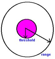
Walter Christaller
developed the Central Place theory to explain the size and spacing of
cities that specialize in selling goods and services.
The theory consists of two basic concepts:
1) threshold -- the minimum market needed to bring a firm
or city selling goods and services into existence and to keep it in business
2) range -- the average maximum distance people will travel
to purchase goods and services
Concentric Zone Model
In 1925, Burgess presented a descriptive urban land use model, which divided cities in a set of concentric circles expanding from the downtown to the suburbs. This representation was built from Burgess' observations of a number of American cities, notably Chicago, for which he provided empirical evidence. The model assumes a relationship between the socio-economic status (mainly income) of households and the distance from the CBD. The further from the CBD, the better the quality of housing, but the longer the commuting time. Thus, accessing better housing is done at the expense of longer commuting times (and costs). According to this monocentric model (see above figure), a large city is divided in six concentric zones:
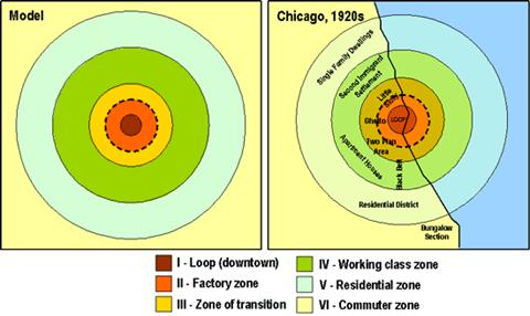
According to Burgess, urban growth is a process of expansion and reconversion of land uses, with a tendency of each inner zone to expand in the outer zone. On the above figure, zone II (Factory zone) is expanding towards zone IV (Working class zone), creating a transition zone with reconversion of land use. Although the Burgess model is simple and elegant, it has drawn numerous criticisms:
However, the Burgess model remains useful as a concept explaining concentric urban development, as a way to introduce the complexity of urban land use and to explain urban growth in American cities in the early-mid 20th century.
Sector and Nuclei Urban Land Use Representations
A study of residential areas done in 1939 by Hoyt in the North American context concluded that the land use pattern was not a random distribution, nor sharply defined rectangular areas or concentric circles, but rather sectors. Thus the effect of direction was added to the effect of distance. Communication axes, such as rail lines and major roads, are mainly responsible for the creation of sectors, thus transport has directional effect on land uses. Cities would thus grow along major axis. The sector representation also includes concentric transitional processes observed by Burgess, which is occurring along axis.
Following Hoyt’s development of a sectorial city, Harris and Ullman (1945) introduced a more effective generalization of urban land uses. It was brought forward that many towns and nearly all large cities do not grow around one CBD, but are formed by the progressive integration of a number of separate nuclei in the urban pattern. These nodes become specialized and differentiated in the growth process and are not located in relation to any distance attribute, but are bound by a number of attributes:
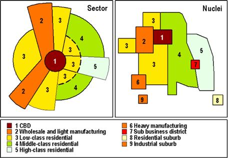
Harris and Ullman polynuclear
model was the first to represent the fragmentation of urban areas, specialized
functions as well as suburbanisation.
Functional Character of Contemporary
Cities
Changing Employment Mix
As economies change, cities change along with them. After all, cities are the
cultural landscape of industrial and economic activities. Cities have an
economic base, which is comprised of two sectors: the basic sector and the
nonbasic sector. The basic sector refers to jobs that produce something that is
sold outside the city; that is, the output is exported resulting in an inflow of
money. On the other hand, jobs in the nonbasic sector, while they are necessary,
do not bring new money into the city. Most people are engaged in activities that
are a blend of these two, rather than simply being one or the other. City
leaders are constantly searching for factories and other basic employment
because of the multiplier effect. That is, one basic job will produce two to
four jobs; nonbasic jobs and will enable the city to increase its tax base.
At one time, there was quite a bit of discussion about the functional specialization of cities, and work was done to classify cities according to their primary function. This work has proved to be somewhat of a dead-end because cities are so diverse. In the 1940s, you could see maps that showed cities that were predominantly manufacturing or retail, university towns, hospital towns, or mining towns, but today with the economic expansion, most cities would fall under the diversified city category. However, classifying allows students to think about why cities exist and how they might change. One of the great changes occurring in the cities today is the process of deindustrialization of industrial sites. Therefore, there has been a diminution of jobs associated with heavy industry and an increase in the number of jobs in the service category.
Changing Demographic and Social Structures Cities have always attracted migrants. Because cities in the industrial world normally need workers, and the source of workers shifts from time to time, there is a constant change in the origin of migrants to a city, which makes cities diverse. This process of migration is discussed in more depth in the Population section of the course.
Built Environment and Social Space
Transportation and Infrastructure
As the Borchert model
indicates, the location of cities was highly influenced by transportation
technologies. Similar processes affected the nature of cities themselves, and
so, as transportation technologies changed, the nature of cities' infrastructure
and landscape also changed. It is possible to classify cities into categories
that closely match Borchert's epochs. First is the Walking/Horse-Cart Era;
second is the Streetcar Era; third, the Recreational Automobile Era; and fourth,
the Automobile Era. The Walking/Horse-Cart Era ended in the late 19th century
with the invention of the electric streetcar. The Streetcar Era or mass transit
era continued until the beginning of the mass production of automobiles. The
Recreational Automobile Era began in the 1920s when the upper class began to use
personalized transportation systems, while the majority of population still rode
streetcars.
The balance between automobiles and streetcars continued until the post-World War II decades when the shift to automobiles took place in North America. In other parts of the world, mass transportation systems (either surface cars or subways) continued to dominate, and the automobile did not prevail until the end of the century. Most industrial cities are now a combination of mass transit and automobile transportation. This mixture of technology promotes social inequalities and is responsible for creating some special segregated landscapes.
As we look into the
future, it is not easy to see what will happen to transportation. The forecast
of the decline of the automobile based on increased cost seems to have been
poorly founded. Although the cost of transportation continues to rise, people
seem willing to pay more for the privacy, mobility, and freedom of choice
associated with automobile transportation. The other unknown is the impact of
computer technology and the ability to substitute the movement of information
for the movement of individuals. It is too early to see how that will impact the
structure of cities, although many predict dispersal of population through the
development of telecommunications.
Different urban transport systems have different operational speeds and
capacities. The car is obviously the least efficient urban transport mode in
terms of capacity (between 1,000 and 3,000 persons per hour), but the fastest.
Urban transit modes, such as the bus, light transit and urban railway are better
fitted for mass urban transportation but at the expense of flexibility in
terms of frequency of services and entry points in the transit systems.
Political Organization of Urban Areas Initially, cities were governed in very straightforward way. As suburbanization developed and people tried to avoid the governments of the interior cities -- which they viewed as corrupt -- a whole host of minor civil governments developed. Today's metropolitan areas are divided into a plethora of political constituencies ranging from school districts to modern shared management areas, specialized service districts, full municipal governments, and in some cases, a kind of metropolitan planning or government organization. The same pattern is found in other parts of the world. South Africans, however, seem to have broken through the intellectual logjam around city governments and have developed a way to expand the political boundaries of cities and reduce the number of cities to achieve the goals of economic development.
It is very hard to predict what will happen to government structures in urban areas. In the 1960s, there were enthusiastic discussions about the rise of metropolitan governments in Toronto and the Twin Cities of Minneapolis and St. Paul. Entrenched political structures have prevented any significant movement toward metropolitan government. There has been some movement toward exchange of wealth through revenue sharing. That is, some wealthy jurisdictions will share their tax incomes with the less wealthy, but the procedure is quite limited.
Urban Planning and Design
Cities are frequently located
on sites that have unstable environmental conditions, such as floodplains or
active seismic zones. Japanese cities are famous for the measures their
architects have taken as a precaution against earthquakes. Cities built on
floodplains and coasts are sometimes subject to flooding. Most cities are
developed in ways intended to minimize the impact of environment on urban life.
For example, cities are paved and sewered to speed up runoff, and cities develop
ways to cope with snow or heat. Occasionally, dramatic environmental forces
overtake urban life, and a hurricane may devastate a large swath of urbanized
area. In fact, because of heavy urbanization of the portions of the United
States subject to hurricanes, the amount of wealth lost and the value of damage
caused by storms continues to increase. Students should not be left with the
perception that the environment has changed; rather, cities are being developed
in places that are prone to conditions such as hurricanes, floods, tornadoes,
and seismic forces.
Uneven Development, Ghettoization, and Gentrification
Observers of industrial
cities and cities of the mercantile era of the Middle East point out that all
these landscapes are shaped by forces of segregation and separation. Arab cities
had clear-cut quarters and divided ethnic groups. Many of these quarters were
walled, with gates that were shut at night. As industrial society developed,
sociologists argue, there was a need for specialized places of residence because
of the need for social status. Because of the increased capacity for production,
middle-class people began to dress like upper-class people. The elite realized
that they had to withdraw to homogeneous quarters to separate themselves from
the status-seeking middle and lower classes. In addition to this social
segregation, people have long wished to avoid economic activities that are
blighting and unpleasant. Thus, citizens sorted themselves according to wealth
and in response to the location of amenities in the landscape.
In addition, the development of new transportation systems changed the relative location of parts of the city. The old core areas, which were developed during the railroad and river transportation eras, were less accessible in the era of automobiles and freeways, whereas suburban areas were more so. As a result, by the end of the twentieth century, manufacturing jobs were more frequently found at the edge of the city than in the core. This produced a mismatch between potential employees among the lower-income population residing in the city centers and the availability of jobs in the suburban development zones. Geographers argue that there is a conscious effort to devalue some parts of the city so that capitalists can come in and make huge profits. While that theory is far from being proven, it is clear that some parts of the landscape are less valued and less attractive for residential development.
Ghettoization is a different process. It refers to the legal restriction of people to certain areas. This was a widespread practice in the Mediterranean and in Europe. The practice was transported to North America and other parts of the colonial empires by the imperialists; thus all cities dominated by the global economy have some form of ghettoization. The term "ghettoization" has, of course, been redefined to mean more simply a concentration of a certain group to a certain area against their will, not necessarily legally but through paralegal practices and practices of social discrimination. Ghettoization is different from separation of people by income. Ghettos refer to areas where populations of mixed income are confined to a certain area even though they might have the means and desire to move.
Gentrification is still another activity. It is a process through which higher-income people repopulate an area that was once an upper-class neighborhood but was later abandoned and taken over by lower-income people. The phenomenon of gentrification began in the 1960s in London and other large cities where rather low-paid white-collar workers were employed in the central business district. They became frustrated with the cost of their long-distance commutes and moved into areas in the center cities where they were able to rent or buy conveniently located larger housing units at a low cost. However, these places were in disrepair and in neighborhoods that were thought to be dangerous and a very risky investment. The proponents of gentrification argue that the alternative was to have these places continue to deteriorate until they had to be condemned and pulled down. Low-income owners or renters could not afford the cost of rehabilitating the buildings.
Patterns of Race, Ethnicity, Gender, and Class The segregation process, discussed earlier in regard to the nature of the internal structure of North American cities and cities around the world, has produced very obvious patterns in the distribution of people by race, ethnicity, class, and gender. Far and away the most powerful force in locating groups is their ability to pay for space. This produces general sorting by economic class that characterizes cities all around the world. The wealthy are able to have choices and choose high-amenity locations in comfortable surroundings. The middle-class buy what they can afford, seeking to emulate the landscapes and lifestyles of the high-income populations. People with limited or no incomes are relegated to the lowest-quality housing in the locations with the least desirable features. In some cultures, governments have intervened to create alternatives to the landmark. These public housing developments vary remarkably in quality and location. In some areas, the public housing is quite satisfactory. Though not luxurious, it provides pleasant surroundings for low-income individuals and families. In other areas, public housing has failed to provide a safe and secure neighborhood for any individuals.
To the degree that there is a
correlation between race or ethnicity and class, a similar pattern of population
distribution can be found. In the United States, for example, where such a
correlation is significantly strong, it is possible to find large areas where
certain populations live in high-quality housing while other populations live in
low-quality housing. This could be observed in the 1920s when the great northern
migration of African Americans occurred. Several programs, both official and
unofficial, were developed in the northern cities to keep African Americans
confined to certain parts of the city. These practices were finally declared
illegal during the administration of Lyndon Johnson and the civil rights acts of
the 1960s and early 1970s. It is not correct to say that one ethnic group
prefers to live in one sort of housing or one sort of neighborhood. The group's
location is a result of when they arrive in the city and what groups are already
there, what space is available, and how much individual groups can afford to
pay. In most cities, ethnic groups such as the Japanese are not concentrated at
all. Other groups, such as Hispanic and Native American populations, are found
in striking concentrations in North American cities. It is also possible to see
some specific concentration of gender groups in cities. In recent years,
neighborhoods have developed safe, comfortable places for gays and lesbians.
Another pattern is the concentration of largely female single groups in
apartment complexes in the suburban or freeway zones or downtown. Still another
striking trend is the rise in female-headed households in two types of
locations: low-income, single mothers concentrated in cheap housing close to
downtown; and middle- and upper-income single parents (notably middle-class
divorcees) located close to suburban amenities in areas deemed to be safe.
Impacts of Suburbanization and Edge Cities
The expansion of cities has
been the topic of all the components in the cities and land-use section. The
most recent discussions of suburbanization have pointed out that the development
of the suburban office and retail shopping clusters off major freeways,
particularly the ring roads and ring ways, has produced landscapes that are very
much like the old downtowns of the streetcar era. This means that in the
intersections of the highway network, we find offices, residences, and in many
locations extensive entertainment venues. These concentrations have caused
people to describe the new suburban landscape as an edge city. The edge cities
promote discontinuity within metropolitan areas because people in the suburban
zone relate to the nodes in the edge rather than the downtown; they therefore
have an action space that is quite limited to their section of the metropolitan
area.
There were a hundred thousand shapes and substances of incompleteness, wildly mingled out of their places, upside down, burrowing in the earth, aspiring in the earth, moldering in the water, and unintelligible as in any dream. - Charles Dickens on London in 1848; Garreau calls this quote the "best one-sentence description of Edge City extant."
They're called suburban business districts, major diversified centers, suburban cores, minicities, suburban activity centers, cities of realms, galactic cities, urban subcenters, pepperoni-pizza cities, superburbia, technoburbs, nucleations, disurbs, service cities, perimeter cities, peripheral centers, urban villages, and suburban downtowns but the name that's now most commonly used for places that the foregoing terms describe is "edge cities."
The term "edge cities" was coined by Washington Post journalist and author Joel Garreau in his 1991 book Edge City: Life on the New Frontier. Garreau equates the growing edge cities at major suburban freeway interchanges around America as the latest transformation of how we live and work. These new suburban cities have sprung up like dandelions across the fruited plain, they're home to glistening office towers, huge retail complexes, and are always located close to major highways.
The archetypal edge city is Tysons Corner, Virginia, outside Washington, D.C. It's located near the junctions of Interstate 495 (the D.C. beltway), Interstate 66, and Virginia 267 (the route from D.C. to Dulles International Airport). Tysons Corner wasn't much more than a village a few decades ago but today it's home to the largest retail area on the east coast south of New York City (that includes Tysons Corner Center, home to six anchor department stores and over 230 stores in all), over 3,400 hotel rooms, over 100,000 jobs, over 25 million square feet of office space. Yet Tysons Corner is a city without a local civic government; much of it lies in unincorporated Fairfax County.
Garreau established five rules for a place to be considered an edge city:
1. The area must have more than five million square feet of office space (about the space of a good-sized downtown)
2. The place must include over 600,000 square feet of retail space (the size of a large regional shopping mall)
3. The population must rise every morning and drop every afternoon (i.e., there are more jobs than homes)
4. The place is known as a single end destination (the place "has it all;" entertainment, shopping, recreation, etc.)
5. The area must not have been anything like a "city" 30 years ago (cow pastures would have been nice)
Garreau identified 123 places in a chapter of his book called "The List" as being true edge cities and 83 up-and-coming or planned edge cities around the country. "The List" included two dozen edge cities or those in progress in greater Los Angeles alone, 23 in metro Washington, D.C., and 21 in greater New York City.
Garreau speaks to the history of the edge city:
Edge Cities represent the third wave of our lives pushing into new frontiers in this half century. First, we moved our homes out past the traditional idea of what constituted a city. This was the sububranization of America, especially after World War II.
Then we wearied of returning downtown for the necessities of life, so we moved our marketplaces out to where we lived. This was the malling of America, especially in the 1960s and 1970s.
Today, we have moved our means of creating wealth, the essence of urbanism - our jobs - out to where most of us have lived and shopped for two generations. That has led to the rise of Edge City. (p. 4)